In the sprawling tapestry of real estate, land development, and civil engineering, boundaries surveyors play a role that, while perhaps unglamorous, is undeniably crucial. Acting as the arbiters of property lines, they establish, re-establish, or verify the physical borders of a property, thereby laying the groundwork for almost all other property-related endeavors. But what exactly does a *boundaries surveyors* do, and why is their role so vital in the grand scheme of things? Let’s delve deeper into the world of boundary surveying.
Who is a Boundary Surveyor?
In essence, boundary surveyors are specialized professionals trained to determine the terrestrial or three-dimensional position of points and the distances and angles between them. These points are often on the surface of the Earth, and they help establish physical boundaries on land maps and property boundaries for ownership, location, or governmental purposes.
The Process: Steps in Boundary Surveying
- Research: Before heading to the field, the surveyor conducts extensive research, combing through historical records, deeds, title certificates, and any other document that can shed light on established boundaries.
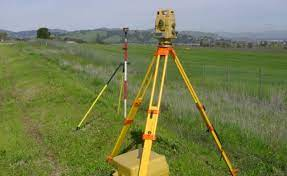
- Fieldwork: Armed with this knowledge, the surveyor then physically measures the land using advanced tools and equipment, ranging from traditional transit and tape to sophisticated GPS devices.
- Analysis: The data obtained from the field is then cross-referenced with the historical research to ensure accuracy.
- Reporting: The final step involves drafting a detailed report, often accompanied by a map or blueprint that delineates the property boundaries.
Boundaries Surveyors: Tools of the Trade
Modern boundary surveyors harness a variety of tools:
- GPS (Global Positioning System): Especially useful for large plots of land, GPS devices can provide highly accurate boundary measurements.
- Total Stations: These devices combine the functionalities of theodolites and EDMs (Electronic Distance Measurement) and are used for detailed plotting and mapping.
- Robotic Total Stations: These allow one surveyor to do the work of two by remotely controlling the total station.
- Drones: Increasingly, boundary surveyors use drones to get a bird’s-eye view of a property, especially useful for inaccessible or hazardous areas.
Importance of Boundary Surveyors
- Ensuring Legal Clarity: Disputes related to property boundaries can become complex and bitter. Having a clearly defined boundary drawn by a professional can prevent or resolve such disputes.
- Supporting Real Estate Transactions: Before purchasing property, it’s essential to know its exact boundaries to ensure the accuracy of the transaction and the legitimacy of the purchase.
- Facilitating Development: For construction projects, understanding where a property begins and ends is crucial to comply with local regulations and to ensure the rightful development of the area.
- Protecting Property Rights: Whether you’re looking to fence your property, build a structure, or plant trees, knowing your property’s exact boundaries ensures you don’t infringe on someone else’s land.
Challenges in Boundary Surveying
- Ambiguity in Historical Records: Old deeds or maps may be imprecise or based on landmarks that no longer exist.
- Physical Obstacles: From dense forests to swamps, the terrain can sometimes make boundary surveying a challenging endeavor.
- Cultural and Societal Barriers: In some areas, local customs and unofficial land claims can challenge the officially recognized boundaries, requiring tact and diplomacy on the part of the surveyor.
Choosing the Right Boundary Surveyor
If you find yourself in need of local surveyor from a boundary surveyor, it’s essential to ensure they:
- Have the Necessary Qualifications: This often includes a degree in surveying or civil engineering and licensing from a recognized local authority.
- Are Experienced: As with many professions, there’s no substitute for experience in boundary surveying. Those who’ve been in the field longer are often more adept at handling the myriad challenges that can arise.
- Use Modern Equipment: The accuracy of boundary surveying is often contingent on the tools used, so ensure your chosen surveyor is up-to-date in this regard.
Boundary Disputes

Boundaries are invisible lines that define disputed boundary and the extent of land ownership, but when disagreements arise regarding these lines, they can escalate into heated disputes. Boundary disputes are more than just conflicts about land; they’re often deeply emotional matters tied to one’s sense of home and security.
What is a Boundary Dispute?
A boundary dispute arises when two or more parties have a disagreement about the location of a property line or other legal boundary there. This boundary agreement can involve homeowners, businesses, or even governmental entities. The disputes can be about small pieces of land or larger territories.
Common Causes of Boundary Disputes
- Ambiguous Language in Deeds: Older deeds might describe boundaries with references to natural markers like trees or streams, which can change or disappear over time.
- Inaccurate Surveys: Mistakes or outdated methods in past surveys can lead to discrepancies in boundary lines.
- Overlapping Claims: This occurs when different deeds appear to give ownership of the same piece of land to different parties.
- Encroachments: One party might build a structure, like a fence or shed, that intrudes onto a neighboring property.
- Adverse Possession: This legal doctrine allows someone to acquire a right over a piece of land if they’ve occupied it continuously and openly for a certain period, even if they don’t have a legal title to it.
Impacts of Boundary Disputes
- Emotional Stress: Disputes can strain relationships between neighbors, leading to hostility and mistrust.
- Financial Implications: Litigating a boundary dispute can be costly, especially if it drags on for years.
- Property Value: Ongoing disputes can decrease property value or make it harder to sell.
Strategies for Resolving Boundary Disputes
- Open Communication: Start by discussing the issue amicably with the other party. A simple conversation can sometimes clear up misunderstandings.
- Hire a Surveyor: A professional boundary surveyor can re-examine the disputed area and provide a current, accurate depiction of the boundary.
- Mediation: Neutral third-party mediators can help both sides come to a mutually beneficial resolution without resorting to litigation.
- Legal Advice: Consulting with an attorney who specializes in property or real estate law can provide clarity on legal rights and potential solutions.
- Court Adjudication: If all else fails, taking the matter to court might be the only option. This should be seen as a last resort due to the costs and time involved.
What is a Land Registry Title Plan?
The Land Registry Title Plan is an official map or plan registered with a land registry office that graphically depicts the extent of a registered title to a piece of land. It’s an essential part of the land registration process in many jurisdictions and provides a clear and concise visual representation of property boundary beyond what’s described in the title deed.
Why is the Land Registry Title Plan Important?
- Verification of Boundaries: It provides a clear way to ascertain the exact boundaries of a property, reducing the risk of disputes.
- Legal Evidence: In case of boundary disputes or other legal conflicts related to the property, the title plan serves as an authoritative piece of evidence.
- Informed Decisions: For potential buyers, understanding the exact dimensions and limitations of a property is crucial to making an informed purchase decision.
- Supports the Title Register: The title plan complements the written description found in the title register, providing a visual interpretation of the title’s extent.
What is a Chartered Land Surveyor?
A Chartered Land Surveyor is a professional who has achieved a specific level of competency, knowledge, and expertise in the field of land surveying and has been granted “chartered” status by a recognized professional body or institution. The term “chartered land law one” often signifies that the surveyor has not only met rigorous educational and experience requirements but also adheres to a strict code of ethics.
Ordnance Survey Mapping
For anyone with an interest in maps or a need to understand the geography of the United Kingdom, the term “Ordnance Survey” (OS) will undoubtedly resonate. As the national mapping agency of the UK, Ordnance Survey is the organization behind the most detailed and comprehensive maps of the country.
Conclusion
Boundary land surveyors, with their blend of historical research, on-ground precision work, expert witness, and legal understanding, are the unsung heroes of land ownership and development. Their work forms the foundation upon which our societies, quite literally, are built. Whether you’re a homeowner curious about the extents of your backyard, a developer readying for a new project, or a governmental body aiming to document and clarify land ownership, the services of a boundary surveyor are indispensable. In a world where every inch can count, their precision and expertise ensure clarity, fairness, and peace of mind.
You can find more information on our website, Andrew Pridell Associates